First Heatwave

- Advertisement -

After three years relatively cooler conditions – (Splashed in the media as – La Nina) – El Nino has arrived with a third week October heatwave on the cards!

- Advertisement -

We had a taste of the hot weather with 34.7C Monday and 34.8C Tuesday.

Followed by a strong SETW (South East Trade Wind) and cloud trapped under the inversion with 28.4C maximum Wednesday.

Merv at the Coastguard said the early warning had the boats tucked in around the islands before the 30 knots (56kph) gusts and four metre waves hit Keppel Bay.

The winds blew thick smoke from the Deepwater Fire (last report 3600 hectares) over Tannum and Gladstone reaching Rocky Wednesday.

Carnarvon still burns (week six?) and Mt. Alma/Dumgree Fire has been around for a couple of weeks. Fire started by a fatal plane crash on the Darling Downs was promptly put out by local farmers.

Be fire smart – don’t let the fire start? At Kabra quick back burning saved dwellings during the week. Hats off to the quick thinking ‘man on the land’, there will be more to come.

Fires in the NT/WA are pushing smoke over 2/3000km into the Indian Ocean.

Reports of over 70 fires in NSW.

This Fire Season is starting to rank in the top end of historical events.

All due to the lack of rainfall and dry conditions with ‘fuel’ available around the country.

Since August Rockhampton has had technically seven rain days.

Highest was five millimetres on 31 August with rest close to one millimetre.

That equates to 82 non rain days.

Even the ‘Gumboot’ country is flagging, we are super dry!

Only Queensland rainfall (mm) I could scavenge up fourth week was – Proserpine 12, Tewantin 8, Whyanbeel 5, Alva 4, Cape Moreton 3, Paluma 2, Coolangatta 2 – all coastal SETW showers.

INTERNATIONAL

GHANA

Torrential rain caused floods displacing thousands of people in the Volga region Tuesday/Wednesday..

USA

Tropical Storm Phillipe is expected to cause tropical rain and rough seas on the Leeward Islands. Before tracking northward.

Tropical Storm Rina was the 17th named storm this season.

It formed about 3000km east of the Caribbean on Thursday.

BRITISH ISLES

Storm Babet after causing floods in Midleton/Cork in Ireland moved to the UK.

The Met Office issued a rare Red Weather Warning (last RED Alert was 2020) for eastern Scotland.

In the town of Brechin schools were closed and 400 homes were told to evacuate.

Meteorologist Jason Kelly forecasts falls of 100-150mm with a possible 200-220mm causing flooding on Friday.

Could break the all time record of 238mm in 1974.

GUAM

Super Typhoon Bolaven started just to the south east of Guam as a low about the 10 October.

Got to Typhoon status 12z on the 11th October.

Inside 24hr Super Typhoon status by the 12th causing very large swells.

It then tracked north east losing strength and below typhoon status by the 16th.

FORECAST

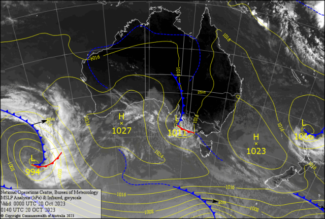
The low near South Australia should move east and cause heavy rain (50-100mm) and floods for Tasmania over the weekend.

Then a second low may reach and develop extreme gale force winds with squally showers for the Apple Isle mid week.

This should affect Victoria.

Meanwhile a ridge along the east coast over the weekend makes way for a trough over western Queensland.

Should reach the east coast Monday.

In the north, tropical cloud is showing signs of gathering in the Solomons. Could cause a rare October Tropical Low. Fueled with the hotter than normal Sea Surface Temperatures.

It may reach Cyclone status.

How “Lo-La” will it go? Before Fiji (or NZ) names the entity.

New Caledonia will be in the firing line!?

May be a small scare for north Queensland?

This combined effect will cause a heatwave for most of eastern Queensland.

Expect maximums to sneak into the 40’s for the Central Highlands.

And the mid thirties for western Capricornia; from Sunday to maybe Friday.

This early heatwave may the sign of more to come for the warmer months.

If you are 64 and under four stay inside the door between 10 and 4.

Only relief will be along the coast with afternoon sea breezes gusting over 40-45kph.

Only hope is an SETW ramping up Friday or Saturday.

Question is? – Is there a rogue thundery with it?

- Advertisement -